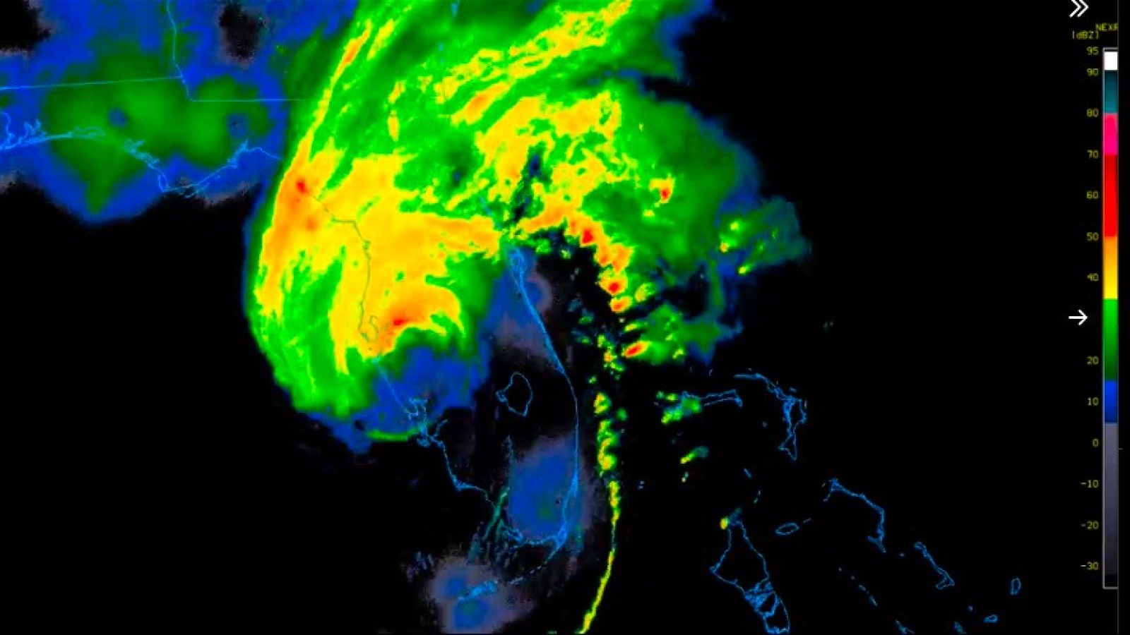
As of 11:50 PM EST, Hurricane Milton has made landfall. Reports are suggesting that the eye of the storm collapsed as it came inland, which is generally a good sign. The storm is still incredibly dangerous, and is not even close to being over. But I wanted to bring an update, and a wild video showing a 15 foot storm surge recorded somewhere on Florida’s western coast in the last few hours.
Here is what a 15 foot hurricane storm surge looks like folks. pic.twitter.com/XVQmw5XAbu
— Eric Feigl-Ding (@DrEricDing) October 9, 2024
Here are the latest bullet points as of just as of this update from NBC News:
- Hurricane Milton made landfall at 8:30 tonight near Siesta Key, Florida, as a Category 3 storm. Siesta Key is a barrier island next to Sarasota.
- At 11 p.m., the center of the storm was around 75 miles southwest of Orlando. Its maximum sustained winds were 105 mph, making it a Category 2 hurricane.
- Deaths have been confirmed in St. Lucie County on Florida’s Atlantic coast, where officials said tornadoes touched down.
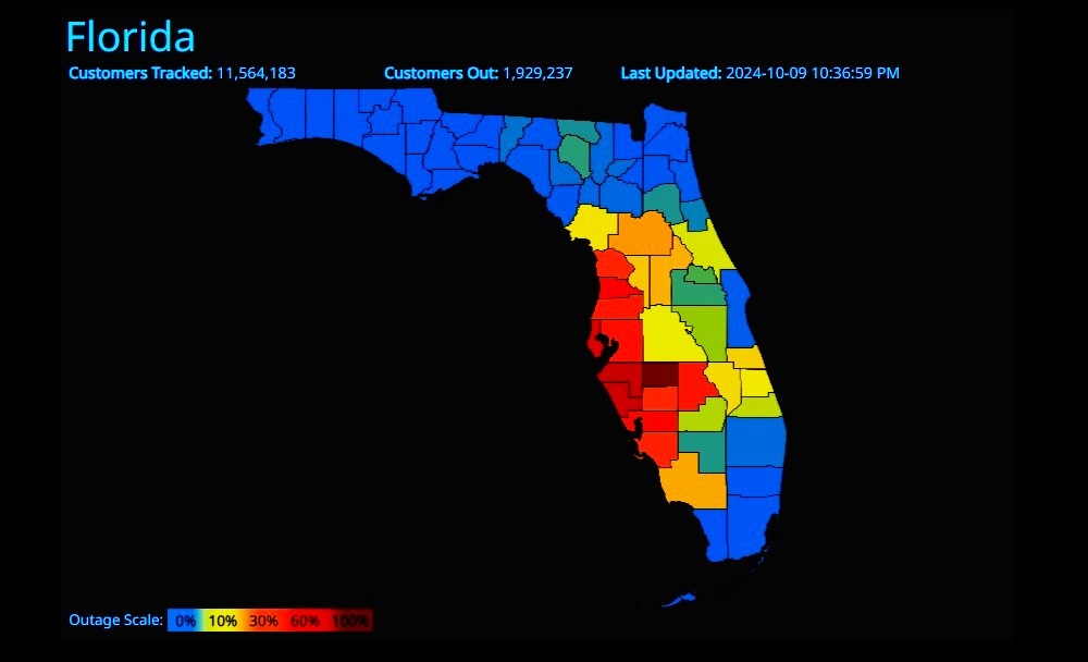
- There were more than 1.7 million utility customers without electricity in Florida around 11 p.m., according to poweroutage.us.
Although it has weakened slightly since it made landfall, Milton is expected to retain hurricane intensity the entire time it travels across the Florida Peninsula, the National Hurricane Center said.
ADVERTISEMENTThe hurricane was a Category 2 storm and was “bringing devastating rains and damaging winds” across parts of Florida at 11 p.m., the agency said in an advisory, after it made landfall on Florida’s western coast this evening.
The center of the storm was about 75 miles southwest of Orlando, with maximum sustained winds of around 105 mph, the National Hurricane Center said. It was traveling east-northeast at 16 mph.
According to poweroutage.us this is the following info for the state of Florida:

——————————————–
With Milton being tracked 100+ miles offshore, conditions in Florida have been nothing short of catastrophic all day. The sheer number of monster tornadoes that have spawned from the outer bands of Milton are hard to keep track of.
And now, with more than 2 hours before Hurricane Milton makes landfall, the flooding in Florida has already become severe in many places. Areas that normally do not flood at all are now under water, and Milton hasn’t even come ashore yet!
Storm surge inundates El Jobean, Florida, and Fort Myers as Hurricane Milton makes its presence felt.
#hurricanemilton #milton #hurricane #stormsurge #flood #flooding #weather #Florida pic.twitter.com/avjpgtAYNb— The Tank (@TheTankGuns) October 9, 2024
That is the scene just a short time ago in the Fort Myers area. And here is a video uploaded within the last few minutes showing a neighborhood in South Venice, Florida with streets completely covered by water, and houses getting very close to taking on flood water.
Here's a look at a South Venice, #Florida Live Cam just now as you can see #StormSurge is flooding the streets as Cat3 #HurricaneMilton approaches. 😬 #flwx #Milton @NWSTampaBay pic.twitter.com/aH3b1QBJ9p
— LiveCamChaser (@LiveCamChaser) October 9, 2024
Here’s a look at a South Venice, #Florida Live Cam just now as you can see #StormSurge is flooding the streets as Cat3 #HurricaneMilton approaches. 😬 #flwx #Milton @NWSTampaBay pic.twitter.com/aH3b1QBJ9p
— LiveCamChaser (@LiveCamChaser) October 9, 2024
For context, this next video is from somewhere on the East Coast of Florida! If the situation wasn’t so dire and the conditions expected in the next few hours so terrible — this would be an awesome “rain day” to have with my kids! Of course, reality is… this is a harbinger of bad things to come. Just the “quiet” before the storm; even for those on the EAST coast of Florida.
I’m on the East Coast of Florida.
Here’s the scene out my front door. #FloridaFlooding #FloridaStrong pic.twitter.com/ZYTMPPtQKB
— Payton Minzenmayer (@thepaytonminz) October 9, 2024
According to a CNN Weather story, conditions are rapidly intensifying along Florida’s west coast as the storm moves closer to landfall:
Extremely heavy rainfall across the Tampa area will continue and spread across Central Florida this evening, increasing the risk of life-threatening flash flooding.
“An axis of extreme rainfall, stretching from the Tampa metropolitan region northeastward into the north-central Florida Peninsula, is expected to result in major to locally catastrophic
flash flooding with considerable threats to life and property,” the Weather Prediction Center warned.
ADVERTISEMENTOver 6 inches of rain has already fallen in Tampa and the WPC is warning of an additional 5 to 8 inches in the next six hours. Rainfall rates could be as high as 2 to 3 inches an hour.
“Some locations could experience rainfall rates in excess of 1 inch per hour for 2-4 hours, causing rapid rises of water above the surface as water will not have sufficient time to drain, especially across the mostly impervious surfaces of the St. Petersburg into the Tampa metro and possibly nearing Orlando later tonight.”
The following report is from Charlotte Harbor, which as you can see is already completely inundated with floodwater. They are expecting a 9-13 foot storm surge in this area!
BREAKING REPORT: Charlotte Harbor,
Florida UNDER WATER with Milton still 2 hours off shore..9-13 foot storm surge expected in Sarasota, FL..
Extreme wind warning for Tampa to Bradenton.. pic.twitter.com/mZm2GEwKX7
— Chuck Callesto (@ChuckCallesto) October 9, 2024
BREAKING REPORT: Charlotte Harbor,
Florida UNDER WATER with Milton still 2 hours off shore..9-13 foot storm surge expected in Sarasota, FL..
Extreme wind warning for Tampa to Bradenton.. pic.twitter.com/mZm2GEwKX7
— Chuck Callesto (@ChuckCallesto) October 9, 2024
Severe flooding in Sarasota as Hurricane Milton moves closer. Streets are inundated, and flashing transformers are adding to the dangerous conditions.
Watch Live Cameras: https://t.co/0tslWRRPqP#HurricaneMilton #Hurricane #Florida #Tampa #Weather #Milton pic.twitter.com/4VDxNo3nbS
— Raw Reporting (@Raw_Reporting) October 9, 2024
The initial footage on this video shows the Sarasota area — also, completely under water!
Severe flooding in Sarasota as Hurricane Milton moves closer. Streets are inundated, and flashing transformers are adding to the dangerous conditions.
Watch Live Cameras: https://t.co/0tslWRRPqP#HurricaneMilton #Hurricane #Florida #Tampa #Weather #Milton pic.twitter.com/4VDxNo3nbS
— Raw Reporting (@Raw_Reporting) October 9, 2024
Florida weather is insane right now. Giant tornadoes, the hurricane getting ready to come ashore, and it's already flooding in areas that normally don't flood.
If you're the praying type, please pray for our fellow Americans.
image: @ryanhallyall pic.twitter.com/tTDGMHkUTl— Shel 🇺🇸🎶🧡🤎 (@Shel_Is_Tired) October 9, 2024
USA Today is reporting that the National Weather Service has warned residents to SHELTER-IN-PLACE at this point, as it has now become impossible to evacuate from the path of the hurricane.
TAMPA, Fla. − The National Weather Service warned residents to shelter-in-place as conditions deteriorated Wednesday evening while Hurricane Milton roared toward Florida’s beleaguered west coast.
“The northern eyewall of Hurricane Milton is beginning to move onshore of the Florida gulf coast near Tampa and St. Petersburg,” the National Hurricane Center said in a 7 p.m. ET update, adding the storm was 35 miles from Sarasota and moving northeast at 15 mph. At that pace, it would make landfall around 9 p.m.
ADVERTISEMENTTropical-storm-force winds, flooding rains and tornadoes were spreading inland as the fierce hurricane was closing in on making landfall. Milton’s sustained winds have tapered off from 145 mph to 120 mph − bringing it down to a Category 3 hurricane − but the storm has grown in size, making its potential damage more widespread.
Front yard, backyard. Probably get some walking catfish 🐟.. That was the first round. 🤦🏼♀️ I still have power for now. #hurricanemilton2024 🌀#FloridaFlooding 🧜🏻♀️🌊 pic.twitter.com/wzhEvVrHgl
— Rhonda (Mermy) (@rkmeeks72) October 9, 2024
I’m not exactly sure where Rhonda filmed the above from, but from what I’m seeing she is catching a break compared to the average conditions across the state.
Here’s another look at Fort Myers, Florida just 30 minutes before publishing this article. Conditions look ominously quiet, apart from a steady wind and enough water to already be dangerous.
FORT MYERS FLOODING
Park Ave & Palm Beach Blvd in Ft. Myers is currently under water. #Milton #flwx pic.twitter.com/zwdSUI5j6I— Lauren Kreidler (@WeatherWithLaur) October 9, 2024
For all those in the path of Hurricane Milton, and for all those who are still trying to survive the aftermath of Hurricane Helene, know that there are a lot of us praying for you — and preparing to respond tangibly as soon as the storm passes. Stay safe, Americans.


Join the conversation!
Please share your thoughts about this article below. We value your opinions, and would love to see you add to the discussion!