[ UPDATE: 10/7 – 8:00PM EST ] — As the need to evacuate parts of Florida become more urgent, road conditions have been changing throughout the day. As of this update, reporter Breanna Morello (a Florida resident) is reporting I-75 North appears clear and passable.
If you’re being told to evacuate, LEAVE!
Do not let people on social media try to deter you.
If we’ve learned anything over the years, it’s that no one is coming to save you.
— Breanna Morello (@BreannaMorello) October 7, 2024
UPDATE: I have not hit traffic on I75 heading north.
I stopped at two gas stations and they all had fuel.
Do not let the rumors of traffic and fuel shortages deter you from leaving.
Please leave if you’re told to evacuate.
I75 heading south has dozens of lineman heading… pic.twitter.com/htaaNsUlrS
— Breanna Morello (@BreannaMorello) October 7, 2024
—————————————
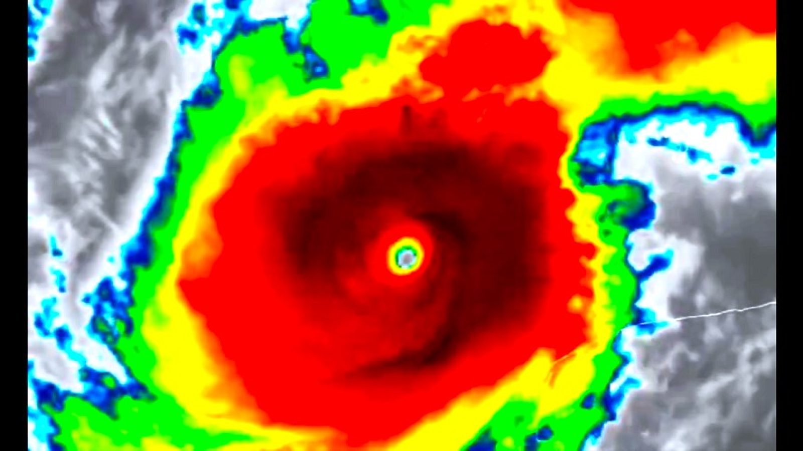
WARNING: In a rapidly developing situation, Hurricane Milton in the Gulf is currently breaking records. In under 3 hours the already dangerous storm exploded from a CAT 2 to CAT 5 as it barrels towards the Florida coast. It is currently tied for the 4th strongest hurricane in Atlantic history, and considering that it is continuing to rapidly intensify — could become the strongest hurricane ever recorded.
Hurricane Milton is undergoing one of the fastest rapid intensifications ever observed in the Atlantic.
It is now a 155 mph Category 4 storm, just 2 mph shy of Category 5 status.
Not a single weather model predicted the storm would strengthen this quickly. pic.twitter.com/lqX76Ryvqv
— Colin McCarthy (@US_Stormwatch) October 7, 2024
10/07/24 11am Major Hurricane Milton Update
⚠️Now a Category 5 Hurricane
⚠️If the storm stays on the current track, it will be the worst storm to impact the Tampa area in over 100 years.
⚠️Please evacuate if told to do so.
⚠️Complete all prep before tomorrow night. #flwx pic.twitter.com/Cq9tJsfr2A— NWS Tampa Bay (@NWSTampaBay) October 7, 2024
The National Weather Service currently puts the timeline for Milton’s pass over Florida as follows, with an expected landfall sometime Wednesday:

According to the latest AccuWeather report, food and water are both becoming scarce as Florida prepares for a direct hit from Milton. AccuWeather is currently forecasting a 10-15 foot storm surge just north of the Tampa Bay area, and a possible 20 foot storm surge around the Sarasota area.
Food and water is flying off the shelves and gas stations are running dry and boarding up as Floridians rush to prepare for Hurricane Milton. “Hurricane Helene [is] still fresh in everybody’s mind,” AccuWeather storm chaser Aaron Rigsby said on Monday while reporting from Tampa, Florida. He added that hardware stores are also busy as people start to board up their windows.
“Milton may be a historic, once-in-a-lifetime storm for Floridians,” AccuWeather Chief Meteorologist Jon Porter said. “Milton has the potential to become one of Florida’s most damaging and costly hurricanes,” he added, in part due to the extreme storm surge expected around and south of Tampa Bay.
AccuWeather is forecasting a storm surge of 10 to 15 feet from just north of Tampa through fort Myers. The worst storm surge is expected around Sarasota and along Longboat Key, where the surge may approach 20 feet, which is taller than most single-story homes. “Should an intense Milton track just north of Tampa, storm surges of 20 feet could occur in parts of Tampa Bay, resulting in widespread, catastrophic damage not seen in this part of Tampa Bay in modern history,” Porter added.
Florida Governor Ron DeSantis just gave an update covering the moves the state is making to expedite the recovery process in advance, including deploying the Florida National Guard and Florida State Guard.
Milton has been upgraded to a CATEGORY 5 HURRICANE.
Florida is in the middle of a MASSIVE evacuation effort.
Now
😳 Imagine if the docks were closed and fuel and supplies were stuck offshore.
Pro-active leaderships matters people. pic.twitter.com/wLMssFNjiq
— Janine Curran (@janinereturns) October 7, 2024
This was the situation as Milton sat on the verge of intensifying from a CAT 4 to a CAT 5 a short time ago. At the time sustained winds were only 2 mph shy of the CAT 5 rating – which it quickly surpassed just following this report:
Hurricane Milton is undergoing one of the fastest rapid intensifications ever observed in the Atlantic.
It is now a 155 mph Category 4 storm, just 2 mph shy of Category 5 status.
Not a single weather model predicted the storm would strengthen this quickly. pic.twitter.com/lqX76Ryvqv
— Colin McCarthy (@US_Stormwatch) October 7, 2024
According to Fox Weather, mandatory evacuations are picking up speed along the coast of Florida, and the National Hurricane Center is warning that the storm is continuing to “explosively intensify”:
Mandatory evacuations are underway across the west coast of Florida as millions of residents prepare for life-threatening impacts from Hurricane Milton, which continues to rapidly intensify over the warm waters of the Gulf of Mexico and strengthened into a powerful Category 5 storm with winds of 175 mph.
The National Hurricane Center said Milton continues to “explosively intensify” and is urging residents to follow directions from local officials if told to leave.
At 175 mph, Milton is the strongest Atlantic hurricane in 5 years since Hurricane Dorian in 2019. Milton is also tied for the fourth strongest storm since record keeping began. Hurricane Allen with 190 mph winds holds the record for the strongest Atlantic hurricane.
The situation is becoming more dire in Florida, with state and local officials warning residents that the time to prepare for the life-threatening storm is running out. They say people near the coast or living in low-lying areas need to get out before the storm approaches and brings with it a potentially deadly storm surge that could reach up to 12 feet in some spots, including Tampa Bay.
There are reports of congested traffic as evacuations pick up speed in Florida, as well as reports coming out of the same area that gas stations are running out of fuel, creating the danger of vehicles getting trapped along evacuation routes with fuel supplies already allegedly running low in some locations:
ALERT – Hearing from a reliable source that Florida residents on the Gulf Coast who are evacuating to the North on I-75 are finding NO FUEL. Nearly all gas stations wiped out. Vehicles will soon be stalled on the interstate, blocking evacuations. Already bumper-to-bumper traffic…
— HealthRanger (@HealthRanger) October 7, 2024
I'm in Bradenton FL and there are gas station running out of fuel. Get and go get some now . Anywhere from here up north to Tampa . Act quick guys #hurricanemilton
— Cody Mack (@ElEstrada17) October 7, 2024
Pinellas County Tropical Storm Milton prep update.
The first 4 gas stations near me were out of gas ⛽️
Found a @Shell on East Lake Road in Palm Harbor with a line. Good news – that means they still have some. Filling up. pic.twitter.com/uqFfZoZ32I
— Alexandre Lores 🇺🇸🇨🇦🇨🇺 (@alexandre_lores) October 6, 2024
Took over an hour just to find a gas station that wasn't out of gas yet or having to wait in long lines 😩😭🥴 #HurricaneMilton
— 𝓖𝓵𝓮𝓷𝓲𝓼𝓱𝓪 🌺🐆♈ (@Always_Glenisha) October 7, 2024
This is a video taken from the air over an evacuation route in Florida. Law enforcement is reporting backups and traffic jams are common as people try to get out of the way of Milton’s fury.
🚨𝐓𝐫𝐚𝐟𝐟𝐢𝐜 𝐀𝐥𝐞𝐫𝐭🚨
Please be advised that I-75 between Morris Bridge and Bruce B Downs is experiencing significant backups. I-275 northbound heading into Pasco County is also seeing heavy traffic, with significant slowdowns starting at 275 and Livingston Avenue.
We… pic.twitter.com/1KpLXXUK5h
— HCSO (@HCSOSheriff) October 7, 2024
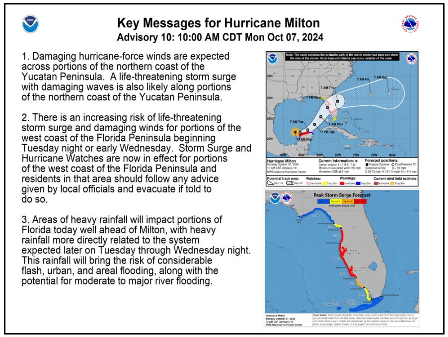
The National Weather Service currently has the following advisory message updated as of 10:00AM CDT on their website regarding Hurricane Milton:

Hurricane Milton’s Sustained Winds have now reached over 175MPH, making it Tied as the 4th Strongest Hurricane in Atlantic History; as Pressure continues to drop we may be on the Verge of one of the Strongest Hurricanes ever in the Northern Atlantic. pic.twitter.com/RpQ50IlLte
— OSINTdefender (@sentdefender) October 7, 2024
Senator Marco Rubio from Florida put out this message just a few minutes ago, warning that the forecasted severity of the storm matches precisely the “worst case” scenario he was shown when he asked what it would look like:
Several years ago I asked @NHC_Atlantic to show me what the worst case storm hitting Florida would look like
What they showed me back then is almost identical to the #Milton forecast now pic.twitter.com/vJOrGfa8eg
— Marco Rubio (@marcorubio) October 7, 2024
This is a developing story as Hurricane Milton is forecasted to continue strengthening as it makes its way towards landfall along the western Florida coast. We will update you as information becomes available.


Join the conversation!
Please share your thoughts about this article below. We value your opinions, and would love to see you add to the discussion!